The Gift of South Dakota
Subscriptions to South Dakota Magazine make great gifts!
Subscribe today — 1 year (6 issues) is just $29!
Taming a Wild River
Jun 20, 2018
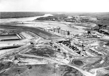
Gen. Lewis A. Pick and Glenn Sloan's names are forever linked as the architects behind the Missouri's series of dams. Less known is that the men could not reach an agreement about the best way to tame the Missouri and grew to despise each other. Their fights were so well known that the Saturday Evening Post compared them to fights over prohibition and women's suffrage.
The men actually came up with two separate plans, each designed to benefit different areas of the river. Gen. Pick, of the Army Corps of Engineers, designed the original plan, enormous in scope. His plan called for 12 multi-purpose dams including five on the Missouri with four in South Dakota. Seven more were designed for the Yellowstone and Republican rivers. Upstream states were not happy. They realized the plan's emphasis on flood control and sustaining a 9-foot channel below Sioux City did not keep their best interests in mind.
They asked Glenn Sloan, a technocrat with the Bureau of Reclamation's regional office in Billings, Montana, to design an alternative. His plan, without surprise, benefitted upstream states by retaining water upstream for irrigation and other purposes. With two vastly different proposals, the men began their famous quarrels.
President Franklin Roosevelt eventually grew frustrated over the men's fighting and suggested they hand control of the project to a Missouri Valley Authority, modeled after the Tennessee Valley Authority. That sparked an attempt to work together.
"No matter how much the Corps of Engineers and Bureau of Reclamation hated each other, they hated the idea of another public corporation even more," wrote Michael Lawson. Another critic, Albert Williams, wrote that they stopped fighting after realizing "the clenched fist is not the best instrument with which to dip into the public trough."
The two agencies created a plan that consisted of just two pages. Instead of compromising, they decided to meld their ideas together, each side agreeing to the other's desires. That left a plan that was not based on a clear vision or purpose. "Everyone pretended there would always be enough water in the Missouri to satisfy all who made claims on her," wrote South Dakota Magazine editor Roger Holtzmann in an article on the building of Fort Randall Dam (in our Jan/Feb 2005 edition).
The shoddily built Pick-Sloan plan transformed much for South Dakotans. We gained a small amount of power over the Mighty Mo — including flood control and hydropower. But the dams also changed the culture of South Dakota. They made possible recreational activities from fishing for walleye and salmon at Lake Oahe to manning a sailboat fit for an ocean on Lewis and Clark Lake.
Those recreational opportunities, which bring in $30 million annually to Lewis and Clark Lake alone, are in danger. Sedimentation is a growing problem — unless man intervenes (again) the entire Lewis and Clark Lake is expected to fill with sediment by the year 2175. Sedimentation issues are occurring in other areas, but are most visible at Lewis and Clark. The grass delta near Springfield advanced nearly a mile to the east during the flood year of 2011. As sediment clogs the flow of the river it affects everything from recreation to flood control to hydropower collection.
There’s no going back. And old-timers tell us we don’t want to return to a day when the river swashed and buckled back and forth between the bluffs at will. Cities, farmsteads and the land itself were fully at the mercy of Mother Nature. And there are days when she shows little mercy. We now have a mostly-managed river system along the 2,300-mile Missouri. The question is how to best manage it for future generations.


Comments
To this day I still think South Dakota has been getting the "short end" of the rope with the Missouri River. I have some pictures of downtown Pierre, SD taken about 1952 or 1953 when there's 18 feet of water upon the buildings. Yes, we gained flood control, fishing and recreation, but at what cost. South Dakota had a couple hundred thousand acres of prime river bottom land put under water with the promise of cheap power, which we question at times, irrigation which years later wasn't going to happen, and of course good drinking water. Why do we have to "beg" money from the government every year to complete projects that were promised to South Dakota in the late 40's?????